ShopDreamUp AI ArtDreamUp
Deviation Actions


![[AGGT] Greater German Empire, 1872](https://images-wixmp-ed30a86b8c4ca887773594c2.wixmp.com/f/1164ffd5-7a08-466e-bb07-0e8165e71bd1/dd1gii6-56261112-e273-46ee-b9f3-148bf53f88a8.png/v1/crop/w_184,h_184,x_0,y_20,scl_0.068022181146026,q_70,strp/_aggt__greater_german_empire__1872_by_altmaps_dd1gii6-92s-2x.jpg?token=eyJ0eXAiOiJKV1QiLCJhbGciOiJIUzI1NiJ9.eyJzdWIiOiJ1cm46YXBwOjdlMGQxODg5ODIyNjQzNzNhNWYwZDQxNWVhMGQyNmUwIiwiaXNzIjoidXJuOmFwcDo3ZTBkMTg4OTgyMjY0MzczYTVmMGQ0MTVlYTBkMjZlMCIsIm9iaiI6W1t7ImhlaWdodCI6Ijw9Mzg4NiIsInBhdGgiOiJcL2ZcLzExNjRmZmQ1LTdhMDgtNDY2ZS1iYjA3LTBlODE2NWU3MWJkMVwvZGQxZ2lpNi01NjI2MTExMi1lMjczLTQ2ZWUtYjlmMy0xNDhiZjUzZjg4YTgucG5nIiwid2lkdGgiOiI8PTI3MDUifV1dLCJhdWQiOlsidXJuOnNlcnZpY2U6aW1hZ2Uub3BlcmF0aW9ucyJdfQ.D7mhNQbwnboSohV0ZS_edlQOa8maGRG61XdnERVugEg)
![[AGGT] Greater German Empire, 1872](https://images-wixmp-ed30a86b8c4ca887773594c2.wixmp.com/f/1164ffd5-7a08-466e-bb07-0e8165e71bd1/dd1gii6-56261112-e273-46ee-b9f3-148bf53f88a8.png/v1/crop/w_92,h_92,x_0,y_10,scl_0.034011090573013,q_70,strp/_aggt__greater_german_empire__1872_by_altmaps_dd1gii6-92s.jpg?token=eyJ0eXAiOiJKV1QiLCJhbGciOiJIUzI1NiJ9.eyJzdWIiOiJ1cm46YXBwOjdlMGQxODg5ODIyNjQzNzNhNWYwZDQxNWVhMGQyNmUwIiwiaXNzIjoidXJuOmFwcDo3ZTBkMTg4OTgyMjY0MzczYTVmMGQ0MTVlYTBkMjZlMCIsIm9iaiI6W1t7ImhlaWdodCI6Ijw9Mzg4NiIsInBhdGgiOiJcL2ZcLzExNjRmZmQ1LTdhMDgtNDY2ZS1iYjA3LTBlODE2NWU3MWJkMVwvZGQxZ2lpNi01NjI2MTExMi1lMjczLTQ2ZWUtYjlmMy0xNDhiZjUzZjg4YTgucG5nIiwid2lkdGgiOiI8PTI3MDUifV1dLCJhdWQiOlsidXJuOnNlcnZpY2U6aW1hZ2Uub3BlcmF0aW9ucyJdfQ.D7mhNQbwnboSohV0ZS_edlQOa8maGRG61XdnERVugEg)
![[AGGT] Division of Hungary (1900)](https://images-wixmp-ed30a86b8c4ca887773594c2.wixmp.com/f/1164ffd5-7a08-466e-bb07-0e8165e71bd1/ddljfn5-dd452bc2-a9d1-4ddd-a32f-df1c2d07ca62.png/v1/crop/w_184,h_184,x_10,y_0,scl_0.10556511761331,q_70,strp/_aggt__division_of_hungary__1900__by_altmaps_ddljfn5-92s-2x.jpg?token=eyJ0eXAiOiJKV1QiLCJhbGciOiJIUzI1NiJ9.eyJzdWIiOiJ1cm46YXBwOjdlMGQxODg5ODIyNjQzNzNhNWYwZDQxNWVhMGQyNmUwIiwiaXNzIjoidXJuOmFwcDo3ZTBkMTg4OTgyMjY0MzczYTVmMGQ0MTVlYTBkMjZlMCIsIm9iaiI6W1t7ImhlaWdodCI6Ijw9MTc0MyIsInBhdGgiOiJcL2ZcLzExNjRmZmQ1LTdhMDgtNDY2ZS1iYjA3LTBlODE2NWU3MWJkMVwvZGRsamZuNS1kZDQ1MmJjMi1hOWQxLTRkZGQtYTMyZi1kZjFjMmQwN2NhNjIucG5nIiwid2lkdGgiOiI8PTIxMzUifV1dLCJhdWQiOlsidXJuOnNlcnZpY2U6aW1hZ2Uub3BlcmF0aW9ucyJdfQ.rZr8KBZMWLdYiCAHm1HOcRZvYm63UDxLKpAf3uuBqw8)
![[AGGT] Division of Hungary (1900)](https://images-wixmp-ed30a86b8c4ca887773594c2.wixmp.com/f/1164ffd5-7a08-466e-bb07-0e8165e71bd1/ddljfn5-dd452bc2-a9d1-4ddd-a32f-df1c2d07ca62.png/v1/crop/w_92,h_92,x_5,y_0,scl_0.052782558806655,q_70,strp/_aggt__division_of_hungary__1900__by_altmaps_ddljfn5-92s.jpg?token=eyJ0eXAiOiJKV1QiLCJhbGciOiJIUzI1NiJ9.eyJzdWIiOiJ1cm46YXBwOjdlMGQxODg5ODIyNjQzNzNhNWYwZDQxNWVhMGQyNmUwIiwiaXNzIjoidXJuOmFwcDo3ZTBkMTg4OTgyMjY0MzczYTVmMGQ0MTVlYTBkMjZlMCIsIm9iaiI6W1t7ImhlaWdodCI6Ijw9MTc0MyIsInBhdGgiOiJcL2ZcLzExNjRmZmQ1LTdhMDgtNDY2ZS1iYjA3LTBlODE2NWU3MWJkMVwvZGRsamZuNS1kZDQ1MmJjMi1hOWQxLTRkZGQtYTMyZi1kZjFjMmQwN2NhNjIucG5nIiwid2lkdGgiOiI8PTIxMzUifV1dLCJhdWQiOlsidXJuOnNlcnZpY2U6aW1hZ2Uub3BlcmF0aW9ucyJdfQ.rZr8KBZMWLdYiCAHm1HOcRZvYm63UDxLKpAf3uuBqw8)


Description
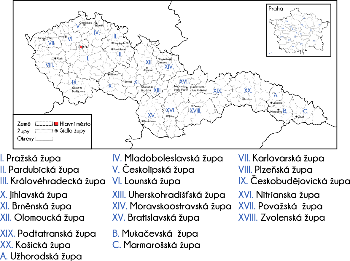
So, while I'm working on some electoral maps for interwar Czechoslovakia and in order not to die of boredom yesterday, I made a map of the administrative divisions of Czechoslovakia between 1920 and 1927. The project, while interesting was a failure for 3 reasons: 1) lack of money, 2) opposition from the Czechoslovak right-wing to its implementation in Czech lands because at least two counties would have a German majority and 3) when implemented in Slovakia and the elections were held in 1923 apparently the results were so bad for the Czechoslovak parties and their Slovak/Hungarian-German allies and so good those of the Slovak nationalists that the results were never published. So, this was always more a de iure idea that never got implemented.
I still thought it was pretty neat though. Czechoslovakia is divided into 'země' (lands), which were to be nominal units; then into 'župy' (counties) with a limited degree of self-governance and autonomy and further subdivided into 'okresy' (districts). The counties were numbered from 1 to 20 (originally 21) in Roman numbers, which I thought was neat and a great example of centralism. Ruthenia, as an autonomous region (more nominally than in reality though) was not a part of this plan, and instead it adopted its own division into 'zup' and 'okresy' on its own.
Same applies for Prague, which remained outside of any county, even from the homonymous one, although it was its capital.
Hopefully I didn't make any mistakes with the words.
Image size
1180x881px 329.59 KB
© 2015 - 2024 nanwe01
Comments8
Join the community to add your comment. Already a deviant? Log In
YES!!!!!!